|
|
Setting up templates for display formatting |
Map Display Templates

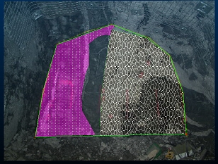
Studio Mapper includes a wide range of display formatting options to give you full control over how your map feature data appears.
These controls are accessible throughout your project session and can also be formed into a template that can be applied to multiple objects, potentially within multiple projects. Display templates are a really useful way to standardize display formatting within your map data, making it easy to differentiate geological structures and attributes.
Setting up a template involves manually creating the display format you want then exporting it to Datamine's proprietary display template format (.3dtpl).
Setting up and exporting a 3D display template...
Once a 3D display template has been exported and stored within the
active Studio Mapper database's "Templates" folder, you
can associate the template with any geological feature object in your
project using your system
configuration file.
Configuration File Template Setup
Any template in any .3Dtpl template file can be assigned to a feature object. Your database can contain one or multiple template files; all will be loaded when a project connected to that database is opened. This makes is easy to share standard formatting throughout your organization.
Providing physical template files are stored in the active databases
"Templates" folder, any template name in any file can be
referenced within a system configuration file, e.g.:
<Features>
<ObjectType>
<Name>Geology</Name>
<Template>GeologyTemplate</Template>
...Other attribute tags are added here...
</ObjectType>
</Features>
In the example above, a template called "GeologyTemplate" is stored within a .3Dtpl file in the current database. Note that it isn't necessary to reference the file name, only the name of a visual template stored within any available file.
Once assigned, open the Studio Mapper project and subsequent digitizing of features will automatically apply the visual formatting associated with the feature object.
For example, if a LITH attribute is configured for the "Geology" feature object, and the associated visual display template contains a legend with intervals that match valid LITH attribute values, you can rapidly create identifiable map features that match accepted visual formatting standards.
|
|
Related Topics |
|
|
3D TemplatesConfiguration File AssignmentConfiguration File ReferenceConfiguration File Example |
Copyright © Datamine Corporate Limited
JMN 20045_00_EN

